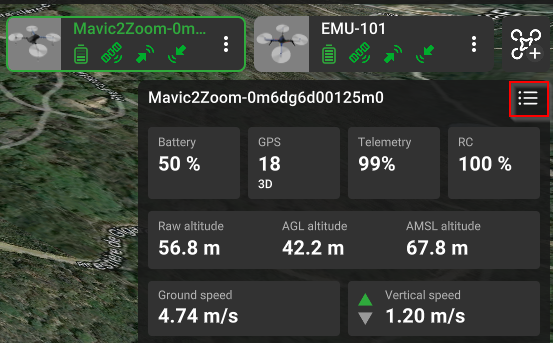
Telemetry window

When the mission is in progress, the telemetry window is shown. Four gauges at the top of the window show the battery charge level, the number of GPS satellites visible, the quality of the downlink channel, and the state of connection to the remote controller. These gauges will have a white, orange, or red color depending on the charge or the quality of the signal.
The next line represents the state of the vehicle – Armed (all systems are activated and the vehicle is ready for flight) or Disarmed (all systems are deactivated and the vehicle is not ready for flight) and control - automatic flight mode or manual mode.
Raw altitude – altitude data sent from the vehicle (without any additional interpretation). This value is based on GPS and/or barometer data.
AGL altitude - shows current vehicle altitude above ground level. The accuracy of this value depends on the digital elevation model of the map for the particular region. The value is calculated thusly: Altitude AGL = Altitude AMSL - Elevation.
AMSL altitude - shows the current altitude of the vehicle above means sea level. This value is based on Raw altitude data. The value is calculated thusly: Altitude AMSL = Take-off point altitude + Raw altitude.
Vertical speed - an indication of how fast a vehicle is ascending or descending. A positive value means an increase in AMSL altitude, and a negative means descending.
Ground speed (Horizontal speed) - horizontal component of the vehicle speed or Ground Speed.
Downlink / Uplink – connection status.
Telemetry is recorded and values are saved to the database. Usually, a vehicle reports its state multiple times per second. All reported data is saved to disk. The telemetry data can take up a large amount of available space.
Updated 3 months ago
